Waterbridge
Posted: Thu Jan 24, 2013 7:35 pm
Hey all,
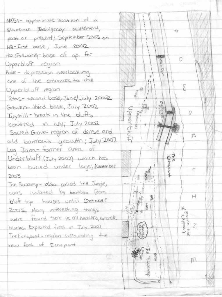
Here's an old map of Waterbridge, my team battlefield for 5 seasons. This is an old version, from right after the Ridgewood Militia started in 2004. One of the original names we had for them was the "Stonewall Insurgency." Their main base at Waterbridge at the time was a log fort called Stonewall, located about where the Nx51 site is marked in The Swamp. I can't remember why we used the Nx51 code for their sites.
There were some changes to the battlefield not reflected in this old map: the log jam got cleared out, and someone extended their back yard down into the swamp there at the bottom. There are also some secret Waterbridge locations from after this map was made that I will not reveal.
Key points to keep in mind:
- The map is oriented north to south. This is not to scale, but the park is about a mile long.
- Vegetation generally gets thicker as you move south.
- On the right bank of the brook, the roughly parallel line shows the extent of vegetation. On the other side of that is a clear strip for a power line.
- The area on the left of the map is higher than the rest. The top of the bluff is denoted by the lines between the shaded residential spots and the brook.
- The dashed line marks the paths in the park.
- The central band is the Ho Ho Kus Brook. The brook has variable depth, but the best places to cross are just below the debris damn and just below the area of the brook in the middle of the map.
- The tree across the brook is an old log. The tree has been there for a long time and is not safe to cross on. In addition to being mostly rotted, the water underneath is not deep deep, so it isn't particularly wise to risk it. At that point, the brook flows between two large stone flood control walls, so if you get caught with your back to it you can't get across the brook there.
- Depending on water levels, there are sometimes sandbars in front of the area marked "Echopont".
- Any and all bases on the map probably don't exist anymore.
- The path climbs in height south of Telos-Groven, and the left bank gets increasingly steep.
The different areas of the battlefield were named over the course of Waterbridge's time on the territory. The names that denote specific locations
- Debris Dam: This is a bunch of rocks early on in the park. Just below this spot is usually a sand bar and a fordable spot. To the left is a wash where a street at the top of the bluff drains into the brook; this was a common spot for ambush attempts. This is the first point where the bluff is actually accessible and where there's enough space to maneuver.
- Upperbluff: This is a wide area of the bluff where there is little undercover but lots of trees.
- Concrete pylon: This block of concrete marks a pipeline passing through the park. It looks like a good spot for an ambush but its a trap. It is easier to get stuck behind it than it is to ambush someone on the path.
- The Ruins, HQ, and the Nx51 sites probably don't exist anymore.
- Telos-Groven was the main Waterbridge complex, but it isn't a very defensible spot.
- Ivy Hill: point where the bluff opens up a bit. The only real undercover is ivy, but the spot would be very defensible with enough people. There are plenty of trees for cover for the defenders, and all the approaches can be clearly seen. The drawback is that there is no water source.
- Sacred Grove: This is a particular dense growth of this one plant we called "bamboo" but which is really some kind of weed. During the Battle of the Fallen Limbs, we hid in there at one point and the RM guys thought we were deer.
- The Swamp is the lowest part of the battlefield and is usually swamp. There are skunk ferns there. A drainage ditch runs along the base of the bluff from behind Telos-Groven, under the path and out to the brook.


